
Bliesquelle topographic map
Interactive map
Click on the map to display elevation.
About this map
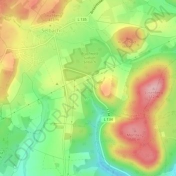
Name: Bliesquelle topographic map, elevation, terrain.
Average elevation: 430 m
Minimum elevation: 352 m
Maximum elevation: 512 m
Other topographic maps
Click on a map to view its topography, its elevation and its terrain.
Dollberg
Deutschland > Saarland > Landkreis St. Wendel > Nohfelden
Dollberg, Nohfelden, Landkreis St. Wendel, Saarland, 54422, Deutschland
Average elevation: 581 m
Bostalsee
Deutschland > Saarland > Landkreis St. Wendel > Nohfelden
Bostalsee, Gonnesweiler, Nohfelden, Landkreis St. Wendel, Saarland, Deutschland
Average elevation: 412 m
Bosenberg
Deutschland > Saarland > Landkreis St. Wendel > Nohfelden
Bosenberg, Nohfelden, Landkreis St. Wendel, Saarland, 66625, Deutschland
Average elevation: 441 m
Bosen
Deutschland > Saarland > Landkreis St. Wendel > Nohfelden
Bosen, Nohfelden, Landkreis St. Wendel, Saarland, Deutschland
Average elevation: 452 m