
Kegelberg topographic map
Interactive map
Click on the map to display elevation.
About this map
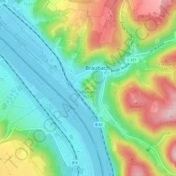
Name: Kegelberg topographic map, elevation, terrain.
Average elevation: 147 m
Minimum elevation: 65 m
Maximum elevation: 292 m
Other topographic maps
Click on a map to view its topography, its elevation and its terrain.
Marksburg
Deutschland > Rheinland-Pfalz > Rhein-Lahn-Kreis > Braubach
Marksburg, Eselsweg, Braubach, Loreley, Rhein-Lahn-Kreis, Rheinland-Pfalz, 56338, Deutschland
Average elevation: 148 m
Eselsberg
Deutschland > Rheinland-Pfalz > Rhein-Lahn-Kreis > Braubach
Eselsberg, Braubach, Loreley, Rhein-Lahn-Kreis, Rheinland-Pfalz, 56338, Deutschland
Average elevation: 224 m