Source du Lac Blanc topographic map
Interactive map
Click on the map to display elevation.
About this map
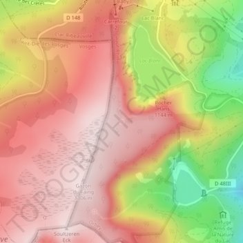
Name: Source du Lac Blanc topographic map, elevation, terrain.
Average elevation: 1,142 m
Minimum elevation: 866 m
Maximum elevation: 1,298 m

Click on the map to display elevation.
Name: Source du Lac Blanc topographic map, elevation, terrain.
Average elevation: 1,142 m
Minimum elevation: 866 m
Maximum elevation: 1,298 m