
Make a donation
Gear up for your next adventure:
As an Amazon Associate, this site earns from qualifying purchases at no extra cost to you.
Egelsbach topographic map
Click on the map to display elevation.
Make a donation
Gear up for your next adventure:
As an Amazon Associate, this site earns from qualifying purchases at no extra cost to you.
Egelsbach
Egelsbach is one of 13 communities in the Offenbach district. The community lies in the Frankfurt Rhine Main Region south of the Main between Frankfurt am Main and Darmstadt at an elevation of 117 m above sea level.
Make a donation
Gear up for your next adventure:
As an Amazon Associate, this site earns from qualifying purchases at no extra cost to you.
About this map
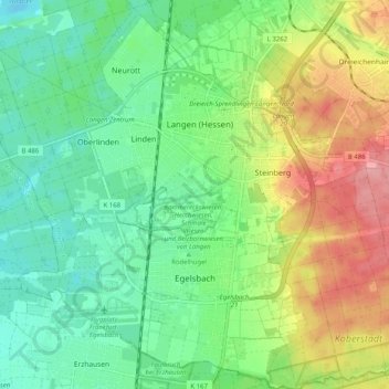
Name: Egelsbach topographic map, elevation, terrain.
Location: Egelsbach, Landkreis Offenbach, Hesse, 63329, Germany (49.94817 8.60412 50.01326 8.70402)
Average elevation: 137 m
Minimum elevation: 99 m
Maximum elevation: 203 m
Make a donation
Gear up for your next adventure:
As an Amazon Associate, this site earns from qualifying purchases at no extra cost to you.
Other topographic maps
Click on a map to view its topography, its elevation and its terrain.