
Thank you for supporting this site ❤️
Make a donation
Make a donation
Gear up for your next adventure:
As an Amazon Associate, this site earns from qualifying purchases at no extra cost to you.
paddar topographic map
Click on the map to display elevation.
Thank you for supporting this site ❤️
Make a donation
Make a donation
Gear up for your next adventure:
As an Amazon Associate, this site earns from qualifying purchases at no extra cost to you.
About this map
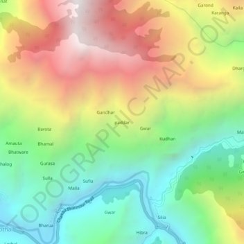
Name: paddar topographic map, elevation, terrain.
Location: paddar, Chamba, Chamba District, Himachal Pradesh, India (32.47209 76.29734 32.51209 76.33734)
Average elevation: 2,030 m
Minimum elevation: 1,187 m
Maximum elevation: 3,157 m
Thank you for supporting this site ❤️
Make a donation
Make a donation
Gear up for your next adventure:
As an Amazon Associate, this site earns from qualifying purchases at no extra cost to you.