Geolocate

Glemsford topographic map

Click on the map to display elevation.

About this map

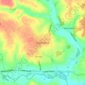
Name: Glemsford topographic map, elevation, terrain.

Location: Glemsford, Babergh, Suffolk, England, United Kingdom (52.08369 0.63726 52.11613 0.69860)

Average elevation: 58 m

Minimum elevation: 29 m

Maximum elevation: 95 m

Other topographic maps

Click on a map to view its topography, its elevation and its terrain.

Sudbury

United Kingdom > England > Suffolk > Babergh

Average elevation: 54 m

Gear up for your next adventure:

🧥Softshell Jackets - Flexible outdoor jackets
🖼️Scratch-off Australia Map - Track the regions and peaks you have explored geographically
💡Collapsible Camping Lanterns - Illuminate your base camp or tent for map studying at night
🛌Sleeping Bags - Sleeping bags for outdoor camping
🧣Merino Neck Gaiters - Versatile headwear for warmth, sun protection, or dust filtering

As an Amazon Associate, this site earns from qualifying purchases at no extra cost to you.