
Make a donation
Gear up for your next adventure:
As an Amazon Associate, this site earns from qualifying purchases at no extra cost to you.
Cherryville topographic map
Click on the map to display elevation.
Make a donation
Gear up for your next adventure:
As an Amazon Associate, this site earns from qualifying purchases at no extra cost to you.
About this map
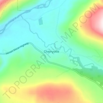
Name: Cherryville topographic map, elevation, terrain.
Average elevation: 643 m
Minimum elevation: 485 m
Maximum elevation: 1,011 m
Make a donation
Gear up for your next adventure:
As an Amazon Associate, this site earns from qualifying purchases at no extra cost to you.
Other topographic maps
Click on a map to view its topography, its elevation and its terrain.
Big Peters Lake
Canada > British Columbia > Regional District of North Okanagan > Area E (Cherryville/East Creighton)
Average elevation: 1,850 m
Monashee Provincial Park
Canada > British Columbia > Regional District of North Okanagan > Area E (Cherryville/East Creighton)
Average elevation: 1,677 m
Spectrum Lake
Canada > British Columbia > Regional District of North Okanagan > Area E (Cherryville/East Creighton)
Average elevation: 1,240 m