
Angeles topographic map
Click on the map to display elevation.
Angeles
Sapangbato is the largest barangay in Angeles in terms of territory, with a total land area of 104,694 sq. meters and a population of 11,262. Located northwest of Angeles near Clark Freeport Zone, it is identified as the barangay in Angeles with the highest elevation of 750 feet above sea level. It is home to Fort Stotsenburg, also known as the Parade Grounds of Clark. apl.de.ap, member of the hip hop group The Black Eyed Peas, hails from Sapangbato. The famous Puning Hot Springs of Barangay Inararo in Porac are accessed through Sitio Target in Sapangbato.
About this map
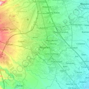
Name: Angeles topographic map, elevation, terrain.
Location: Angeles, Central Luzon, Philippines (15.10817 120.47807 15.17941 120.63715)
Average elevation: 98 m
Minimum elevation: 21 m
Maximum elevation: 312 m
Other topographic maps
Click on a map to view its topography, its elevation and its terrain.
Malolos
Malolos is relatively flat of about 0.81% to a gently sloping of 2.17%. The slope of the land descends towards west, southwest to southern direction. The highest land elevation is at about 6.0 meters above sea level while the lowest is only half a meter below sea level. A network of natural waterways and…
Average elevation: 6 m
Baguio
In 1903, Filipinos, Japanese and Chinese workers were hired to build Kennon Road, the first road directly connecting Baguio with the lowlands of La Union and Pangasinan. Before this, the only road to Benguet was Naguilian Road, and it was largely a horse trail at higher elevations. Camp John Hay was…
Average elevation: 881 m
Quezon City
Founded as a pueblo by Saint Pedro Bautista in 1590, San Francisco del Monte may be considered Quezon City's oldest district. The original land area of the old town of San Francisco del Monte was approximately2.5 square kilometres (1.0 sq mi) and covered parts of what is currently known as Project 7 and 8 and…
Average elevation: 57 m
Vigan
Vigan is situated in a Quaternary Age sedimentary plain called the Vigan-Bantay Plain which is part of the Ilocos coastal plain. The Vigan-Bantay Plain is bounded on the east by a moderately rugged Miocene sediments consisting of interbedded sandstones and shale to very rugged Meta-volcanics and Meta sediment…
Average elevation: 63 m
Dasmariñas
Dasmariñas is partly lowland and partly hilly. The Poblacion itself is elevated. From an elevation of 80 meters (260 ft) at the Poblacion, the land rises to 250 meters (820 ft) towards Silang. Generally, land near rivers and creeks are rugged. Dasmariñas is outside the typhoon belt and has no fault line…
Average elevation: 97 m
Buhi
Buhi has generally mountainous and hilly surface, with 50% of its area having a slope of around 25%. The Poblacion located on the south shore of Lake Buhi, has gently rolling topography.
Average elevation: 161 m
Legazpi
Legazpi's topography is generally plain on the northeastern areas, with slopes ranging from five to fifteen degrees. The southern areas have mostly rolling to hilly terrain. In the city's coastal areas, the terrain varies from plain (north) to hilly (south). Legazpi is criss-crossed by several rivers including…
Average elevation: 150 m
Tuba
Tuba's topography is generally characterized by irregular rugged terrain and steep slopes with several mountain peaks rising from the table land itself. Mount Santo Tomas, the highest peak in the municipality soars to 2,252 metres (7,388 ft) above sea level.
Average elevation: 1,242 m
San Juan
"San Juan" is a contraction of the city's traditional name of "San Juan del Monte" (lit. 'Saint John of the Mountain'). As with numerous other places in the Philippines, the name combines a patron saint and a toponym; in this case Saint John the Baptist with the locale's hilly terrain and relatively higher…
Average elevation: 35 m
Sorsogon City
Sorsogon City covers a land area of 31,292 hectares (120.82 sq mi). It is at the southernmost tip of the Bicol Peninsula and of Luzon Island. The city is bounded by Castilla in the west, Manito in the northwest, Albay Gulf in the north, Prieto Diaz in the east, Gubat in the southeast, Casiguran in the…
Average elevation: 89 m
Pagadian
Philippines > Zamboanga del Sur
About 45% of the total city area is steeply sloping terrain of hills and mountains on the northwestern portion that covers an estimated 15,090 hectares. Mt. Sugarloaf (1,376 m.), Mt. Pinukis (1,213 m.), and Mt. Palpalan (650 m.) are the three notable mountain peaks. Areas in the direct north and central part,…
Average elevation: 169 m
Valenzuela
The highest elevation point is 38 meters (125 ft) above sea level. Having a surface gradient of 0.55% and a gentle slope, hilly landscape is located in the industrial section of the city in Canumay. The average elevation point is 2 meters (6.6 ft) above sea level.
Average elevation: 24 m