
Lago Verde topographic map
Interactive map
Click on the map to display elevation.
About this map
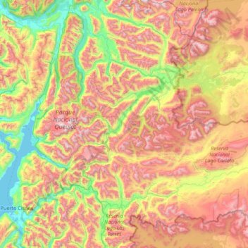
Name: Lago Verde topographic map, elevation, terrain.
Average elevation: 870 m
Minimum elevation: -1 m
Maximum elevation: 2,156 m
Other topographic maps
Click on a map to view its topography, its elevation and its terrain.
Reserva Nacional Lago Carlota
Chile > Región Aysén del General Carlos Ibáñez del Campo > Lago Verde > Lago Verde
Reserva Nacional Lago Carlota, Lago Verde, Provincia de Coyhaique, Región Aysén del General Carlos Ibáñez del Campo, Chile
Average elevation: 942 m