Geolocate

New Hope topographic map

Click on the map to display elevation.

About this map
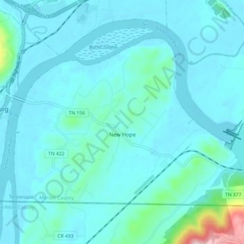
Name: New Hope topographic map, elevation, terrain.

Location: New Hope, Marion County, East Tennessee, Tennessee, 37580, United States (34.98484 -85.69575 35.03226 -85.61149)

Average elevation: 211 m

Minimum elevation: 178 m

Maximum elevation: 500 m

Other topographic maps

Click on a map to view its topography, its elevation and its terrain.

Deadman Eddy

United States > Tennessee > Marion County

Average elevation: 355 m

Haletown

United States > Tennessee > Marion County > Ladds

Average elevation: 286 m

Whiteside

United States > Tennessee > Marion County

Average elevation: 368 m

Sequatchie

United States > Tennessee > Marion County

Average elevation: 260 m

Shake Rag

United States > Tennessee > Marion County

Average elevation: 343 m

Ladds

United States > Tennessee > Marion County

Average elevation: 291 m

Haletown

United States > Tennessee > Marion County

Average elevation: 286 m

Pinhook

United States > Tennessee > Marion County

Average elevation: 304 m

Gear up for your next adventure:

🪢Paracord - Multi-purpose survival cord
🔋Rechargeable Batteries - Eco-friendly power for high-drain GPS units and flashlights
🌿Flora and Fauna Field Guides - Identify the plants and animals you encounter on your route
🎽Base Layers - Thermal base layers
🪑Portable Backpacking Chairs - A comfortable seat for studying maps at the end of the day

As an Amazon Associate, this site earns from qualifying purchases at no extra cost to you.