
Ikeja topographic map
Interactive map
Click on the map to display elevation.
About this map
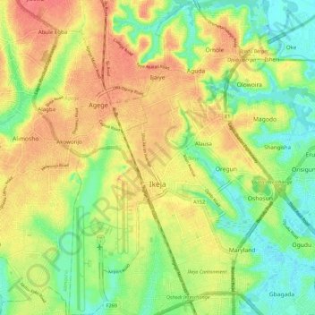
Name: Ikeja topographic map, elevation, terrain.
Location: Ikeja, Lagos State, Nigeria (6.55092 3.31010 6.65866 3.38319)
Average elevation: 29 m
Minimum elevation: -1 m
Maximum elevation: 57 m
Other topographic maps
Click on a map to view its topography, its elevation and its terrain.
Ajegunle
Nigeria > Lagos State > Alimosho
Ajegunle, Alimosho, Lagos State, 100265, Nigeria
Average elevation: 35 m
Lagos
Nigeria > Lagos State > Lagos Island
Lagos, Lagos Island, Lagos State, 100242, Nigeria
Average elevation: 5 m