
Make a donation
Gear up for your next adventure:
As an Amazon Associate, this site earns from qualifying purchases at no extra cost to you.
Oliver topographic map
Click on the map to display elevation.
Make a donation
Gear up for your next adventure:
As an Amazon Associate, this site earns from qualifying purchases at no extra cost to you.
About this map
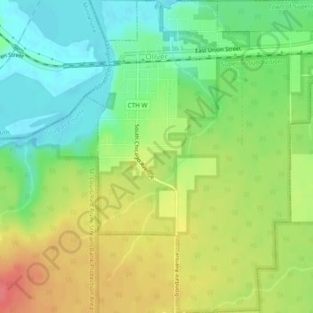
Name: Oliver topographic map, elevation, terrain.
Location: Oliver, Douglas County, Wisconsin, United States (46.63344 -92.20493 46.66265 -92.16978)
Average elevation: 207 m
Minimum elevation: 178 m
Maximum elevation: 243 m
Make a donation
Gear up for your next adventure:
As an Amazon Associate, this site earns from qualifying purchases at no extra cost to you.
Other topographic maps
Click on a map to view its topography, its elevation and its terrain.
Make a donation
Gear up for your next adventure:
As an Amazon Associate, this site earns from qualifying purchases at no extra cost to you.
Big Manitou Falls
United States > Wisconsin > Douglas County > Town of Superior
Average elevation: 295 m