
Make a donation
Gear up for your next adventure:
As an Amazon Associate, this site earns from qualifying purchases at no extra cost to you.
Samlesbury topographic map
Click on the map to display elevation.
Make a donation
Gear up for your next adventure:
As an Amazon Associate, this site earns from qualifying purchases at no extra cost to you.
About this map
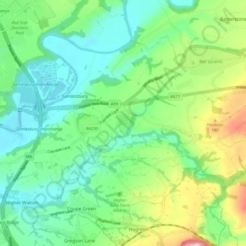
Name: Samlesbury topographic map, elevation, terrain.
Location: Samlesbury, South Ribble, Lancashire, England, United Kingdom (53.74087 -2.64405 53.78283 -2.54555)
Average elevation: 58 m
Minimum elevation: 7 m
Maximum elevation: 176 m
Make a donation
Gear up for your next adventure:
As an Amazon Associate, this site earns from qualifying purchases at no extra cost to you.
Other topographic maps
Click on a map to view its topography, its elevation and its terrain.
Walton Summit
United Kingdom > England > Lancashire > South Ribble > Bamber Bridge
Average elevation: 67 m
Make a donation
Gear up for your next adventure:
As an Amazon Associate, this site earns from qualifying purchases at no extra cost to you.
Roach Bridge
United Kingdom > England > Lancashire > South Ribble > Coupe Green
Average elevation: 49 m
Make a donation
Gear up for your next adventure:
As an Amazon Associate, this site earns from qualifying purchases at no extra cost to you.