Geolocate

Callios topographic map

Click on the map to display elevation.

About this map

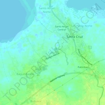
Name: Callios topographic map, elevation, terrain.

Location: Callios, Santa Cruz, Laguna, Calabarzon, 4009, Philippines (14.25574 121.38628 14.29574 121.42628)

Average elevation: 6 m

Minimum elevation: -3 m

Maximum elevation: 15 m

Other topographic maps

Click on a map to view its topography, its elevation and its terrain.

Oogong

Philippines > Laguna > Santa Cruz

Average elevation: 23 m

Bubukal

Philippines > Laguna > Santa Cruz

Average elevation: 10 m

Bagumbayan

Philippines > Laguna > Santa Cruz

Average elevation: 5 m

San Juan

Philippines > Laguna > Santa Cruz

Average elevation: 15 m

Gatid

Philippines > Laguna > Santa Cruz

Average elevation: 5 m

Patimbao

Philippines > Laguna > Santa Cruz

Average elevation: 9 m

Duhat

Philippines > Laguna > Santa Cruz

Average elevation: 8 m

Labuin

Philippines > Laguna > Santa Cruz

Average elevation: 14 m

Barangay V

Philippines > Laguna > Santa Cruz

Average elevation: 4 m

Bubukal

Philippines > Laguna > Santa Cruz

Average elevation: 10 m

Gear up for your next adventure:

🔦Headlamps - Hands-free lighting for hiking
Altimeter Barometer Watches - Outdoor watches with built-in sensors to track altitude changes and weather shifts
🛰️Handheld GPS Units - Rugged GPS devices for tracking coordinates and elevation in the Australian bush
🧺Fast-Dry Microfiber Towels - Large towels that pack down to the size of an orange
👕UPF 50+ Sun Shirts - Essential protection against the harsh Australian sun during field work

As an Amazon Associate, this site earns from qualifying purchases at no extra cost to you.