
Saint-Maurice-du-Désert topographic map
Interactive map
Click on the map to display elevation.
About this map
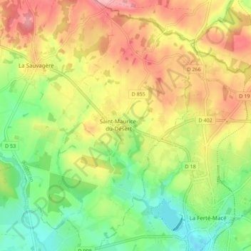
Name: Saint-Maurice-du-Désert topographic map, elevation, terrain.
Average elevation: 242 m
Minimum elevation: 180 m
Maximum elevation: 310 m
Other topographic maps
Click on a map to view its topography, its elevation and its terrain.
Les Nouettes
France > Normandie > Orne > Les Monts-d'Andaine
Les Nouettes, La Sauvagère, Les Monts-d'Andaine, Argentan, Orne, Normandie, France métropolitaine, 61600, France
Average elevation: 252 m