
Make a donation
Gear up for your next adventure:
As an Amazon Associate, this site earns from qualifying purchases at no extra cost to you.
Otterfing topographic map
Click on the map to display elevation.
Make a donation
Gear up for your next adventure:
As an Amazon Associate, this site earns from qualifying purchases at no extra cost to you.
About this map
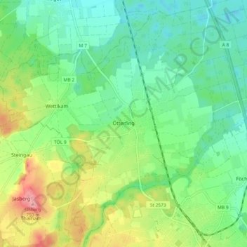
Name: Otterfing topographic map, elevation, terrain.
Location: Otterfing, Landkreis Miesbach, Bayern, 83624, Deutschland (47.88055 11.62346 47.93919 11.71497)
Average elevation: 677 m
Minimum elevation: 639 m
Maximum elevation: 754 m
Make a donation
Gear up for your next adventure:
As an Amazon Associate, this site earns from qualifying purchases at no extra cost to you.
Other topographic maps
Click on a map to view its topography, its elevation and its terrain.
Spitzingsee
Deutschland > Bayern > Landkreis Miesbach > Spitzingsee
Der Spitzingsee liegt etwa fünf Kilometer südlich des Schliersees und wenige hundert Meter südlich des Spitzingsattels auf 1084 m Höhe in den Schlierseer Bergen, Mangfallgebirge, Bayerische Alpen. Mit 28,3 Hektar (0,28 km²) Fläche ist er einer der größten Bergseen Bayerns. Die Seetiefe beträgt maximal…
Average elevation: 1,262 m
Make a donation
Gear up for your next adventure:
As an Amazon Associate, this site earns from qualifying purchases at no extra cost to you.
Make a donation
Gear up for your next adventure:
As an Amazon Associate, this site earns from qualifying purchases at no extra cost to you.
Wallberg
Deutschland > Bayern > Landkreis Miesbach > Rottach-Egern
Der Anstieg von der Wallbergbahn-Talstation bei Rottach-Egern führt über einen Sattel links vorbei am Setzberg (1706 m) zur Bergstation der Wallbergbahn. Das dortige Panoramarestaurant Wallberg liegt in 1623 m Höhe. Nach weiteren 100 Höhenmetern erreicht man über einen Geröll- und Felspfad in etwa…
Average elevation: 1,215 m
Make a donation
Gear up for your next adventure:
As an Amazon Associate, this site earns from qualifying purchases at no extra cost to you.
Make a donation
Gear up for your next adventure:
As an Amazon Associate, this site earns from qualifying purchases at no extra cost to you.
Make a donation
Gear up for your next adventure:
As an Amazon Associate, this site earns from qualifying purchases at no extra cost to you.
Make a donation
Gear up for your next adventure:
As an Amazon Associate, this site earns from qualifying purchases at no extra cost to you.
Make a donation
Gear up for your next adventure:
As an Amazon Associate, this site earns from qualifying purchases at no extra cost to you.
Make a donation
Gear up for your next adventure:
As an Amazon Associate, this site earns from qualifying purchases at no extra cost to you.
Taubenberg
Deutschland > Bayern > Landkreis Miesbach > Warngau
Der Taubenberg ist ein Berg mit 896 m Höhe und einer Ausdehnung von 1847 ha auf dem Gebiet der Gemeinde Warngau, zu einem kleineren Teil auch auf dem Gebiet der Gemeinde Valley, im Landkreis Miesbach. Er liegt abgesetzt vor den Tegernseer Bergen der Bayerischen Voralpen und ist ein beliebtes Wanderziel und…
Average elevation: 783 m
Make a donation
Gear up for your next adventure:
As an Amazon Associate, this site earns from qualifying purchases at no extra cost to you.
Make a donation
Gear up for your next adventure:
As an Amazon Associate, this site earns from qualifying purchases at no extra cost to you.
Wendelstein
Deutschland > Bayern > Landkreis Miesbach > Fischbachau
Der Jahresniederschlag liegt bei 1713 mm in der Referenzperiode 1961–1990 und ist damit im deutschlandweiten Vergleich extrem hoch, da er in das obere Zwanzigstel der in Deutschland erfassten Werte fällt. An 99 % der Messstationen des Deutschen Wetterdienstes werden niedrigere Werte registriert. Im Zeitraum…
Average elevation: 1,374 m
Make a donation
Gear up for your next adventure:
As an Amazon Associate, this site earns from qualifying purchases at no extra cost to you.
Make a donation
Gear up for your next adventure:
As an Amazon Associate, this site earns from qualifying purchases at no extra cost to you.
Wildbad Kreuth
Deutschland > Bayern > Landkreis Miesbach > Kreuth
2015 gab die Hanns-Seidel-Stiftung bekannt, dass der Eigentümer die jährliche Pacht von eher symbolischen 84.000 Euro auf 630.000 Euro erhöhen wolle, jeweils zuzüglich aller Unterhaltskosten. Die Stiftung erklärte, dass sie die Pacht des Gebäudes unter diesen Umständen nicht fortsetzen könne. Die…
Average elevation: 1,021 m
Make a donation
Gear up for your next adventure:
As an Amazon Associate, this site earns from qualifying purchases at no extra cost to you.
Make a donation
Gear up for your next adventure:
As an Amazon Associate, this site earns from qualifying purchases at no extra cost to you.
Anderlmühle
Deutschland > Bayern > Landkreis Miesbach > Hohendilching > Anderlmühle
Average elevation: 637 m
Make a donation
Gear up for your next adventure:
As an Amazon Associate, this site earns from qualifying purchases at no extra cost to you.
Sonderdilching
Deutschland > Bayern > Landkreis Miesbach > Weyarn > Sonderdilching
Average elevation: 631 m
Make a donation
Gear up for your next adventure:
As an Amazon Associate, this site earns from qualifying purchases at no extra cost to you.