
Basingstoke and Deane topographic map
Interactive map
Click on the map to display elevation.
About this map
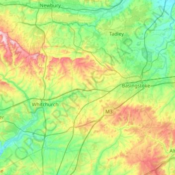
Name: Basingstoke and Deane topographic map, elevation, terrain.
Average elevation: 115 m
Minimum elevation: 39 m
Maximum elevation: 293 m
Other topographic maps
Click on a map to view its topography, its elevation and its terrain.
Cocksford Firs East
United Kingdom > England > Hampshire > Basingstoke and Deane > Steventon
Cocksford Firs East, Steventon, Basingstoke and Deane, Hampshire, England, SO21 3BD, United Kingdom
Average elevation: 153 m
Overton
United Kingdom > England > Hampshire > Basingstoke and Deane
Overton, Basingstoke and Deane, Hampshire, England, United Kingdom
Average elevation: 126 m
North Waltham
United Kingdom > England > Hampshire > Basingstoke and Deane
North Waltham, Basingstoke and Deane, Hampshire, England, United Kingdom
Average elevation: 139 m
Woolton Hill
United Kingdom > England > Hampshire > Basingstoke and Deane
Woolton Hill, Basingstoke and Deane, Hampshire, England, RG20 9UZ, United Kingdom
Average elevation: 126 m
Whitchurch
United Kingdom > England > Hampshire > Basingstoke and Deane > Whitchurch
Whitchurch, Basingstoke and Deane, Hampshire, South East England, England, United Kingdom
Average elevation: 108 m
Sherborne St John
United Kingdom > England > Hampshire > Basingstoke and Deane
Sherborne St John, Basingstoke and Deane, Hampshire, England, RG24 9HP, United Kingdom
Average elevation: 92 m
Ellisfield
United Kingdom > England > Hampshire > Basingstoke and Deane
Ellisfield, Basingstoke and Deane, Hampshire, South East England, England, United Kingdom
Average elevation: 176 m
Kingsclere
United Kingdom > England > Hampshire > Basingstoke and Deane
Kingsclere, Basingstoke and Deane, Hampshire, England, United Kingdom
Average elevation: 139 m