
San Bartolo topographic map
Interactive map
Click on the map to display elevation.
About this map
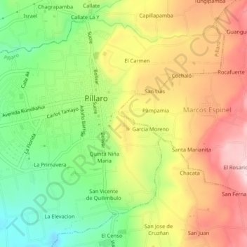
Name: San Bartolo topographic map, elevation, terrain.
Average elevation: 2,820 m
Minimum elevation: 2,668 m
Maximum elevation: 2,979 m
Other topographic maps
Click on a map to view its topography, its elevation and its terrain.
El Carmen
Équateur > Tungurahua > Santiago de Pillaro > Píllaro > El Carmen
El Carmen, Píllaro, Pillaro, Santiago de Pillaro, Tungurahua, 180802, Équateur
Average elevation: 2,844 m