
Wasco County topographic map
Interactive map
Click on the map to display elevation.
About this map
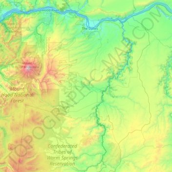
Name: Wasco County topographic map, elevation, terrain.
Location: Wasco County, Oregon, VS (44.82157 -121.80454 45.70495 -120.37142)
Average elevation: 762 m
Minimum elevation: 17 m
Maximum elevation: 3,328 m
Other topographic maps
Click on a map to view its topography, its elevation and its terrain.
Crater Lake National Park
VS > Oregon > Rim Village
Crater Lake National Park, Summit Trail, Rim Village, Klamath County, Oregon, 97604, VS
Average elevation: 1,726 m
Deschutes River
Deschutes River, Jefferson County, Oregon, 97703, VS
Average elevation: 973 m