
Kulangor-Gessela topographic map
Interactive map
Click on the map to display elevation.
About this map
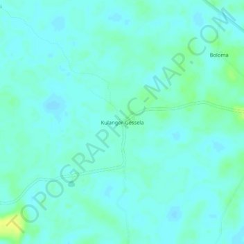
Name: Kulangor-Gessela topographic map, elevation, terrain.
Location: Kulangor-Gessela, Tewor, Grand Cape Mount County, Liberia (6.90228 -11.40865 6.94228 -11.36865)
Average elevation: 7 m
Minimum elevation: 2 m
Maximum elevation: 20 m
Other topographic maps
Click on a map to view its topography, its elevation and its terrain.
Goe
Liberia > Grand Cape Mount County > Tewor
Goe, Tewor, Grand Cape Mount County, Liberia
Average elevation: 34 m