

Big Sur topographic map
Click on the map to display elevation.
About this map
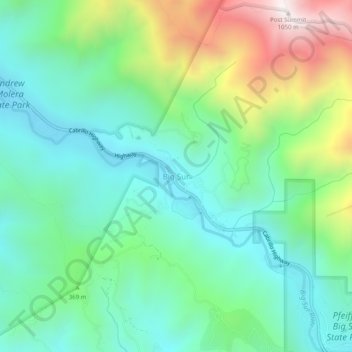
Name: Big Sur topographic map, elevation, terrain.
Location: Big Sur, Monterey County, California, United States (36.25024 -121.82745 36.29024 -121.78745)
Average elevation: 313 m
Minimum elevation: 20 m
Maximum elevation: 1,026 m
Other topographic maps
Click on a map to view its topography, its elevation and its terrain.
Seaside
United States > California > Monterey County
Seaside, formerly East Monterey, is a city in Monterey County, California, United States, with a population of 32,366 as of the 2020 census. It is located 2.25 miles (3.6 km) east-northeast of Monterey, at an elevation of 33 feet (10 m), and is the home of California State University, Monterey Bay (CSUMB), UC…
Average elevation: 69 m
Bradley
United States > California > Monterey County
Bradley is an unincorporated community and census-designated place (CDP) in Monterey County, California, on the Salinas River 14 miles (23 km) south-southeast of San Ardo and 20 miles (32 km) north of Paso Robles. Bradley sits at an elevation of 548 feet (167 m). The population was 69 at the 2020 census, down…
Average elevation: 190 m