
Vila Viçosa topographic map
Interactive map
Click on the map to display elevation.
About this map
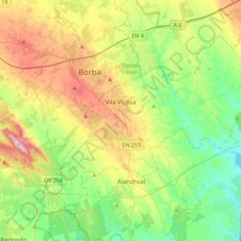
Name: Vila Viçosa topographic map, elevation, terrain.
Location: Vila Viçosa, Évora, Alentejo Central, Alentejo, Portugal (38.67123 -7.49999 38.84802 -7.20738)
Average elevation: 291 m
Minimum elevation: 130 m
Maximum elevation: 502 m
Other topographic maps
Click on a map to view its topography, its elevation and its terrain.
Foz
Portugal > Alentejo > Alcácer do Sal e Santa Susana > Foz
Foz, Santiago, Alcácer do Sal e Santa Susana, Alcácer do Sal, Setúbal, Alentejo Litoral, Alentejo, 7580-126, Portugal
Average elevation: 31 m
Portalegre
Portugal > Alentejo > Portalegre
Portalegre, Alto Alentejo, Alentejo, 7300-139, Portugal
Average elevation: 416 m
Carrasqueira
Portugal > Alentejo > São Gregório e Santa Justa
Carrasqueira, São Gregório e Santa Justa, Arraiolos, Évora, Alentejo Central, Alentejo, 7040, Portugal
Average elevation: 276 m