Geolocate

Isolated topographic map

Click on the map to display elevation.

About this map

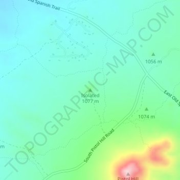
Name: Isolated topographic map, elevation, terrain.

Location: Isolated, Pima County, Arizona, United States (32.07463 -110.65853 32.07473 -110.65843)

Average elevation: 1,052 m

Minimum elevation: 994 m

Maximum elevation: 1,255 m

Other topographic maps

Click on a map to view its topography, its elevation and its terrain.

Catalina

United States > Arizona > Pima County

Average elevation: 936 m

Gear up for your next adventure:

🖼️Scratch-off Australia Map - Track the regions and peaks you have explored geographically
🥾Hiking Shoes - Lightweight hiking shoes for day hikes
📱Shockproof Phone Cases - Extra protection for your smartphone against drops on rocky terrain
🧤Thermal Hiking Gloves - Keep your hands warm and functional during high-altitude winter treks
🔦LED Torches - LED torches for outdoor use

As an Amazon Associate, this site earns from qualifying purchases at no extra cost to you.