
Bình Dương Province topographic map
Interactive map
Click on the map to display elevation.
Bình Dương Province
Bình Dương province is situated on relatively level terrain, and is crossed by the Saigon, Đồng Nai, and Bé rivers. It also has some hills. Bình Dương can be seen from the Lái Thiêu central church. Although Bình Dương is flat, it is higher than Ho Chi Minh City. Across Bình Dương there are many different topographic regions, including low mountainous terrain with slight undulation, flat plains and alluvial valleys. There are some low mountains, including Châu Thới in Dĩ An and Cậu mountain (also called Lấp Vò) in Dầu Tiếng district and some low hills. Natural effects have created many different types of landform including worn areas, accumulative areas (due to the deposition of corrosive materials in the flow) and some areas that are worn, accumulative and depositional at the same time. This is due to rainfall and the flow affecting the ground, with the effects of wind, temperature, climate, the erosion and collapse due to gravity of the geology. The impact took place over millions of years.
About this map
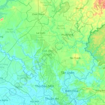
Name: Bình Dương Province topographic map, elevation, terrain.
Location: Bình Dương Province, Vietnam (10.86346 106.32789 11.50159 106.96669)
Average elevation: 38 m
Minimum elevation: -2 m
Maximum elevation: 265 m
Other topographic maps
Click on a map to view its topography, its elevation and its terrain.
Saigon
The city is located in the south-eastern region of Vietnam, 1,760 km (1,090 mi) south of Hanoi. The average elevation is 5 m (16 ft) above sea level for the city centre and 16 m (52 ft) for the suburb areas. It borders Tây Ninh Province and Bình Dương Province to the north, Đồng Nai Province and Bà…
Average elevation: 6 m
Ho Chi Minh City
Ho Chi Minh City is located in the south-eastern region of Vietnam, 1,760 km (1,090 mi) south of Hanoi. The average elevation is 19 metres (62 ft) above sea level. It borders Tây Ninh Province and Bình Dương Province to the north, Đồng Nai Province and Bà Rịa–Vũng Tàu Province to the east, Long…
Average elevation: 6 m
Đà Nẵng
Geologically, Da Nang is at the edge of a Paleozoic fold belt known as the Truong Son Orogenic Zone, whose main deformation occurred during the early Carboniferous period. Da Nang's topography is dominated by the steep Annamite mountain range to the north and north-west, which features peaks ranging from 700…
Average elevation: 52 m