
Make a donation
Gear up for your next adventure:
As an Amazon Associate, this site earns from qualifying purchases at no extra cost to you.
Kammerbach topographic map
Click on the map to display elevation.
Make a donation
Gear up for your next adventure:
As an Amazon Associate, this site earns from qualifying purchases at no extra cost to you.
About this map
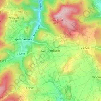
Name: Kammerbach topographic map, elevation, terrain.
Average elevation: 333 m
Minimum elevation: 214 m
Maximum elevation: 480 m
Make a donation
Gear up for your next adventure:
As an Amazon Associate, this site earns from qualifying purchases at no extra cost to you.
Other topographic maps
Click on a map to view its topography, its elevation and its terrain.
Dudenrode
Deutschland > Hessen > Werra-Meißner-Kreis > Bad Sooden-Allendorf
Dudenrode liegt im Geo-Naturpark Frau-Holle-Land (Werratal.Meißner.Kaufunger Wald). Es befindet sich 7,3 km westlich der Kernstadt von Bad Sooden-Allendorf auf 330 m Höhe. Nachbarorte sind der Bad Sooden-Allendorfer Stadtteil Hilgershausen im Nordosten, der Berkataler Ortsteil Frankenhain im Südosten und…
Average elevation: 418 m
Hessische Schweiz bei Meinhard
Deutschland > Hessen > Werra-Meißner-Kreis > Bad Sooden-Allendorf > Hitzelrode
Average elevation: 425 m