
Make a donation
Gear up for your next adventure:
As an Amazon Associate, this site earns from qualifying purchases at no extra cost to you.
Grünwald topographic map
Click on the map to display elevation.
Make a donation
Gear up for your next adventure:
As an Amazon Associate, this site earns from qualifying purchases at no extra cost to you.
About this map
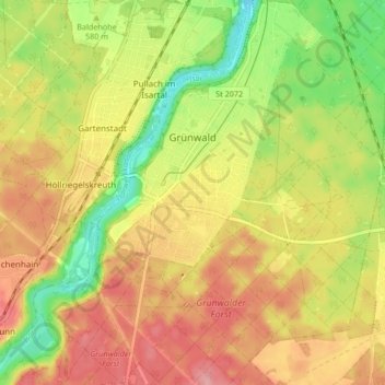
Name: Grünwald topographic map, elevation, terrain.
Location: Grünwald, Landkreis München, Bavaria, 82031, Germany (48.01261 11.50594 48.06846 11.56005)
Average elevation: 589 m
Minimum elevation: 527 m
Maximum elevation: 641 m
Make a donation
Gear up for your next adventure:
As an Amazon Associate, this site earns from qualifying purchases at no extra cost to you.
Other topographic maps
Click on a map to view its topography, its elevation and its terrain.
Deisenhofen
Germany > Bavaria > Landkreis München > Oberhaching > Deisenhofen
Average elevation: 592 m
Feldkirchen
Germany > Bavaria > Landkreis München > Feldkirchen > Feldkirchen
Average elevation: 524 m