Geolocate

Irwin topographic map

Click on the map to display elevation.

About this map
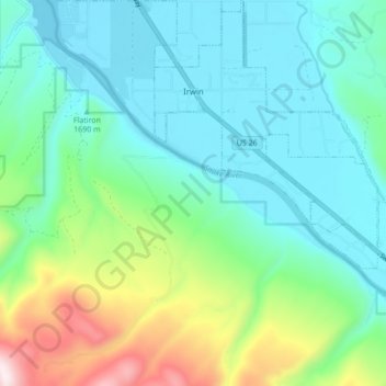
Name: Irwin topographic map, elevation, terrain.

Location: Irwin, Bonneville County, Idaho, United States (43.35945 -111.30495 43.42216 -111.22549)

Average elevation: 1,790 m

Minimum elevation: 1,611 m

Maximum elevation: 2,363 m

Other topographic maps

Click on a map to view its topography, its elevation and its terrain.
Palisades

United States > Idaho > Bonneville County

Average elevation: 1,762 m

Ririe Dam

United States > Idaho > Bonneville County

Average elevation: 1,585 m

Black Mountain

United States > Idaho > Bonneville County

Average elevation: 2,471 m

Ririe Reservoir

United States > Idaho > Bonneville County

Average elevation: 1,720 m

Mount Baldy

United States > Idaho > Bonneville County

Average elevation: 2,089 m

Wheaton Mountain

United States > Idaho > Bonneville County

Average elevation: 1,855 m

Gear up for your next adventure:

🛌Sleeping Mats - Insulated mats for camping comfort
👖Convertible Hiking Trousers - Zip-off legs to adapt to changing temperatures throughout the day
🥤Outdoor Water Bottles - Reusable bottles for outdoor activities
🏫Topographic World Globes - 3D physical relief globes to understand global geography
💧Personal Water Filters - Drink safely from streams and lakes identified on your map

As an Amazon Associate, this site earns from qualifying purchases at no extra cost to you.