
Long Reef topographic map
Click on the map to display elevation.
About this map
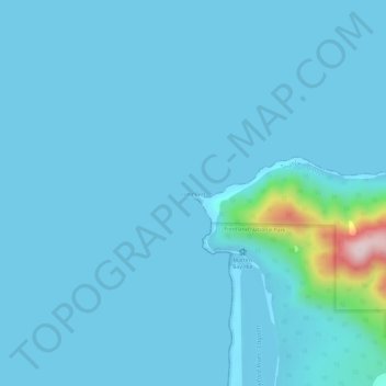
Name: Long Reef topographic map, elevation, terrain.
Location: Long Reef, Southland, New Zealand (-44.33314 167.99360 -44.32411 168.05321)
Average elevation: 26 m
Minimum elevation: 0 m
Maximum elevation: 437 m
Other topographic maps
Click on a map to view its topography, its elevation and its terrain.
Milford Sound
New Zealand > Southland > Southland District > Fiordland Community
Average elevation: 655 m
Forest Range
New Zealand > Southland > Southland District > Waihopai Toetoe Community
Average elevation: 373 m
Ohai
New Zealand > Southland > Southland District > Wallace Takitimu Community
Average elevation: 188 m
Mount Tūtoko
New Zealand > Southland > Southland District > Fiordland Community
Average elevation: 1,892 m
Rakahouka
New Zealand > Southland > Southland District > Waihopai Toetoe Community
Average elevation: 38 m
Garston
New Zealand > Southland > Southland District > Northern Community > Garston
Average elevation: 373 m