
Tukey topographic map
Interactive map
Click on the map to display elevation.
About this map
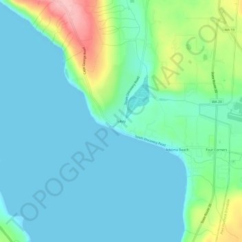
Name: Tukey topographic map, elevation, terrain.
Location: Tukey, Jefferson County, Washington, États-Unis d'Amérique (48.03398 -122.86295 48.07398 -122.82295)
Average elevation: 34 m
Minimum elevation: 0 m
Maximum elevation: 156 m
Other topographic maps
Click on a map to view its topography, its elevation and its terrain.
Port Townsend
États-Unis d'Amérique > Washington > Jefferson County
Port Townsend, Jefferson County, Washington, États-Unis d'Amérique
Average elevation: 19 m