
Kafu River topographic map
Interactive map
Click on the map to display elevation.
About this map
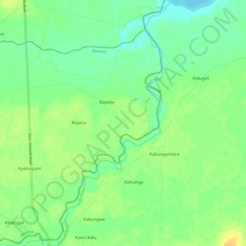
Name: Kafu River topographic map, elevation, terrain.
Location: Kafu River, Kyajongo, Nakasongola, Central Region, Uganda (1.54223 32.02847 1.64841 32.09553)
Average elevation: 1,043 m
Minimum elevation: 1,031 m
Maximum elevation: 1,059 m
The swamp, out of which River Kafu arises, is also transversed by another river system called River Nkusi. River Nkusi however, arises elsewhere and passes through the said swamp and flows westwards to empty into Lake Albert, along the International border between Uganda and the Democratic Republic of the Congo. At its source, River Kafu is an altitude of approximately 1,100 metres (3,600 ft). At its point of entry into River Nile, the altitude is approximately 1,040 metres (3,410 ft).