
Wiltz topographic map
Interactive map
Click on the map to display elevation.
About this map
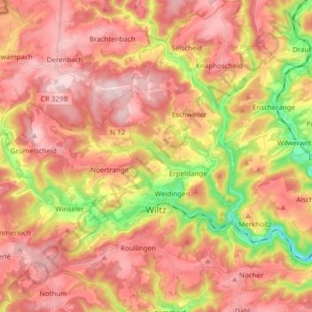
Name: Wiltz topographic map, elevation, terrain.
Location: Wiltz, Canton Wiltz, Luxemburg (49.93454 5.87787 50.03223 5.98019)
Average elevation: 423 m
Minimum elevation: 257 m
Maximum elevation: 530 m
Other topographic maps
Click on a map to view its topography, its elevation and its terrain.
Heiderscheidergrund
Luxemburg > Canton Wiltz > Heiderscheidergrund
Heiderscheidergrund, Esch-sur-Sûre, Canton Wiltz, 9659, Luxemburg
Average elevation: 410 m
Heiderscheid
Luxemburg > Canton Wiltz > Esch-sur-Sûre
Heiderscheid, Esch-sur-Sûre, Canton Wiltz, Luxemburg
Average elevation: 425 m
Pommerloch
Pommerloch, Winseler, Canton Wiltz, 9638, Luxemburg
Average elevation: 442 m