
Make a donation
Gear up for your next adventure:
As an Amazon Associate, this site earns from qualifying purchases at no extra cost to you.
Mattsee topographic map
Click on the map to display elevation.
Make a donation
Gear up for your next adventure:
As an Amazon Associate, this site earns from qualifying purchases at no extra cost to you.
About this map
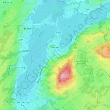
Name: Mattsee topographic map, elevation, terrain.
Location: Mattsee, Bezirk Salzburg-Umgebung, Salzburg, 5163, Austria (47.93441 13.06952 47.99675 13.15124)
Average elevation: 562 m
Minimum elevation: 494 m
Maximum elevation: 788 m
Make a donation
Gear up for your next adventure:
As an Amazon Associate, this site earns from qualifying purchases at no extra cost to you.
Other topographic maps
Click on a map to view its topography, its elevation and its terrain.
Wallersee
Austria > Salzburg > Bezirk Salzburg-Umgebung > Seekirchen am Wallersee > Fischtaging
Average elevation: 531 m
Make a donation
Gear up for your next adventure:
As an Amazon Associate, this site earns from qualifying purchases at no extra cost to you.
Make a donation
Gear up for your next adventure:
As an Amazon Associate, this site earns from qualifying purchases at no extra cost to you.
Make a donation
Gear up for your next adventure:
As an Amazon Associate, this site earns from qualifying purchases at no extra cost to you.