
Make a donation
Gear up for your next adventure:
As an Amazon Associate, this site earns from qualifying purchases at no extra cost to you.
Lukla topographic map
Click on the map to display elevation.
Make a donation
Gear up for your next adventure:
As an Amazon Associate, this site earns from qualifying purchases at no extra cost to you.
Lukla
Lukla village holds a small airport serving the region, and a variety of shops and lodges catering to tourists and trekkers, providing western-style meals and trail supplies. From Lukla, travelers need two days to reach the village of Namche Bazaar, an altitude-acclimatization stop for those continuing on. The airport has a 527-metre (1,729 ft) single asphalt runway, making it the shortest commercial runway in the world.
Make a donation
Gear up for your next adventure:
As an Amazon Associate, this site earns from qualifying purchases at no extra cost to you.
About this map
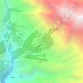
Name: Lukla topographic map, elevation, terrain.
Location: Lukla, Khumbupasanglahmu, Solukhumbu, Koshi Province, Nepal (27.66897 86.71067 27.70897 86.75067)
Average elevation: 2,996 m
Minimum elevation: 1,969 m
Maximum elevation: 4,436 m
Make a donation
Gear up for your next adventure:
As an Amazon Associate, this site earns from qualifying purchases at no extra cost to you.
Other topographic maps
Click on a map to view its topography, its elevation and its terrain.
Make a donation
Gear up for your next adventure:
As an Amazon Associate, this site earns from qualifying purchases at no extra cost to you.