
Gemeinde Bad Vöslau topographic map
Interactive map
Click on the map to display elevation.
About this map
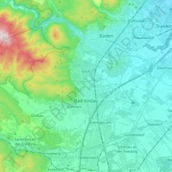
Name: Gemeinde Bad Vöslau topographic map, elevation, terrain.
Location: Gemeinde Bad Vöslau, Bezirk Baden, Lower Austria, Austria (47.94335 16.08584 48.00650 16.25249)
Average elevation: 313 m
Minimum elevation: 194 m
Maximum elevation: 831 m