
La Angostura topographic map
Interactive map
Click on the map to display elevation.
About this map
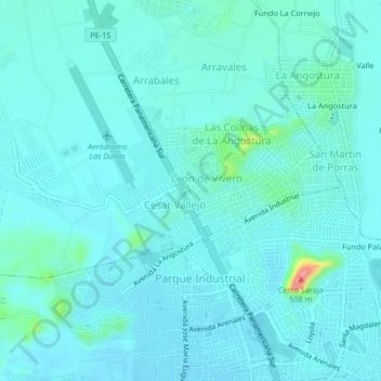
Name: La Angostura topographic map, elevation, terrain.
Location: La Angostura, Subtanjalla, Ica, 11001, Perú (-14.06214 -75.77069 -14.02214 -75.73069)
Average elevation: 418 m
Minimum elevation: 404 m
Maximum elevation: 518 m
Other topographic maps
Click on a map to view its topography, its elevation and its terrain.
Yanquisa
Perú > Ica > Subtanjalla > Virgen de Chapi
Yanquisa, Virgen de Chapi, Subtanjalla, Ica, 11000, Perú
Average elevation: 423 m
Virgen de Chapi
Perú > Ica > Subtanjalla
Virgen de Chapi, Subtanjalla, Ica, 11000, Perú
Average elevation: 423 m
Lovera
Perú > Ica > Subtanjalla > Lovera
Lovera, Subtanjalla, Provincia de Ica, Ica, Perú
Average elevation: 424 m