
Make a donation
Gear up for your next adventure:
As an Amazon Associate, this site earns from qualifying purchases at no extra cost to you.
Canyon Springs topographic map
Click on the map to display elevation.
Make a donation
Gear up for your next adventure:
As an Amazon Associate, this site earns from qualifying purchases at no extra cost to you.
About this map
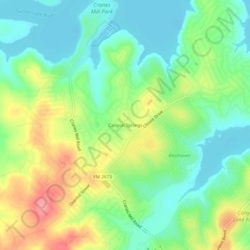
Name: Canyon Springs topographic map, elevation, terrain.
Location: Canyon Springs, Comal County, Texas, 79133, United States (29.85272 -98.30751 29.89272 -98.26751)
Average elevation: 310 m
Minimum elevation: 274 m
Maximum elevation: 369 m
Make a donation
Gear up for your next adventure:
As an Amazon Associate, this site earns from qualifying purchases at no extra cost to you.
Other topographic maps
Click on a map to view its topography, its elevation and its terrain.
Make a donation
Gear up for your next adventure:
As an Amazon Associate, this site earns from qualifying purchases at no extra cost to you.
Make a donation
Gear up for your next adventure:
As an Amazon Associate, this site earns from qualifying purchases at no extra cost to you.
Comal River
United States > Texas > Comal County > New Braunfels > Landa Park Estates
Average elevation: 206 m