
Zoppot topographic map
Interactive map
Click on the map to display elevation.
About this map
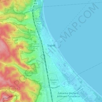
Name: Zoppot topographic map, elevation, terrain.
Location: Zoppot, Aglomeracja Trójmiasta, Woiwodschaft Pommern, Polen (54.41974 18.50448 54.46398 18.59151)
Average elevation: 30 m
Minimum elevation: -1 m
Maximum elevation: 136 m
Other topographic maps
Click on a map to view its topography, its elevation and its terrain.
Zoppot
Polen > Woiwodschaft Pommern > Zoppot
Zoppot, Woiwodschaft Pommern, Polen
Average elevation: 44 m