
Mongar District topographic map
Interactive map
Click on the map to display elevation.
About this map
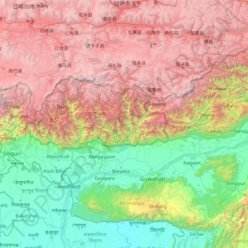
Name: Mongar District topographic map, elevation, terrain.
Location: Mongar District, Bhutan (24.60651 88.49004 29.80651 93.69004)
Average elevation: 2,287 m
Minimum elevation: 2 m
Maximum elevation: 7,505 m
Other topographic maps
Click on a map to view its topography, its elevation and its terrain.
Misina
Bhutan > Punakha District > Barp Gewog > Gamakha Sebtokha
Misina, Gamakha Sebtokha, Barp Gewog, Punakha District, Bhutan
Average elevation: 1,490 m
Gangkhar Puensum
Bhutan > Gasa District > Lunana Gewogs > Thangza_Toenchoe
Gangkhar Puensum, Thangza_Toenchoe, Lunana Gewogs, Gasa District, Bhutan
Average elevation: 6,616 m
Bondey
Bhutan > Paro District > Lamgong Gewog > Bondey
Bondey, Lamgong Gewog, Paro District, 12001, Bhutan
Average elevation: 2,402 m
Thimphu
Bhutan > Thimphu District > Thimphu
Thimphu, Chang Gewog, Thimphu, Thimphu District, 11001, Bhutan
Average elevation: 3,121 m
Khangkhu
Bhutan > Paro District > Khangkhu
Khangkhu, Paro Dzongkhag, Paro District, 12001, Bhutan
Average elevation: 2,454 m