Geolocate

Uludağ topographic map

Click on the map to display elevation.

Uludağ

Uludağ (Turkish pronunciation: [ˈuɫudaː]), the ancient Mysian or Bithynian Olympus (Greek: Όλυμπος), is a mountain in Bursa Province, Turkey, with an elevation of 2,543 m (8,343 ft).

Wikipedia (CC-BY-SA 3.0)

About this map

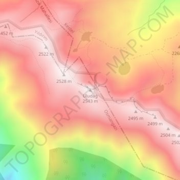
Name: Uludağ topographic map, elevation, terrain.

Location: Uludağ, Osmangazi, Bursa, Marmara Region, Turkey (40.07048 29.22196 40.07058 29.22206)

Average elevation: 2,265 m

Minimum elevation: 1,698 m

Maximum elevation: 2,535 m

Other topographic maps

Click on a map to view its topography, its elevation and its terrain.

Adalet Mahallesi

Turkey > Osmangazi

Average elevation: 104 m

Elmaçukur Mahallesi

Turkey > Osmangazi

Average elevation: 965 m

Gear up for your next adventure:

🐍Australian Snake Bite Kits - Specific pressure immobilization bandages for Australian venomous snakes
🔦Headlamps - Hands-free lighting for hiking
👣Snake & Scrub Gaiters - Protection against spinifex, mud, and snakes while walking off-track
🔋Rechargeable Batteries - Eco-friendly power for high-drain GPS units and flashlights
🖼️Scratch-off Australia Map - Track the regions and peaks you have explored geographically

As an Amazon Associate, this site earns from qualifying purchases at no extra cost to you.