Geolocate

Majayjay topographic map

Click on the map to display elevation.

About this map

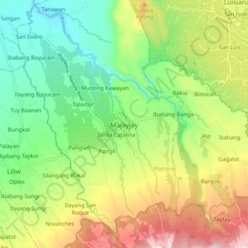
Name: Majayjay topographic map, elevation, terrain.

Location: Majayjay, Laguna, Calabarzon, 4005, Philippines (14.10558 121.43251 14.18558 121.51251)

Average elevation: 328 m

Minimum elevation: 67 m

Maximum elevation: 739 m

Other topographic maps

Click on a map to view its topography, its elevation and its terrain.

Malinao River

Philippines > Laguna > Majayjay > Rizal

Average elevation: 391 m

Gear up for your next adventure:

🍶Collapsible Water Bottles - Save space in your pack as you consume your water supply
🥤Outdoor Water Bottles - Reusable bottles for outdoor activities
🧥Down Jackets - Insulated jackets for cold weather
🎒40L Day Hiking Backpacks - Comfortable packs with hydration support for long days exploring topographic peaks
🧥Insulated Down Jackets - High warmth-to-weight ratio for cold nights in the high country

As an Amazon Associate, this site earns from qualifying purchases at no extra cost to you.