
Make a donation
Gear up for your next adventure:
As an Amazon Associate, this site earns from qualifying purchases at no extra cost to you.
Atwood topographic map
Click on the map to display elevation.
Make a donation
Gear up for your next adventure:
As an Amazon Associate, this site earns from qualifying purchases at no extra cost to you.
About this map
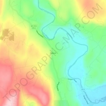
Name: Atwood topographic map, elevation, terrain.
Average elevation: 151 m
Minimum elevation: 53 m
Maximum elevation: 280 m
Make a donation
Gear up for your next adventure:
As an Amazon Associate, this site earns from qualifying purchases at no extra cost to you.
Other topographic maps
Click on a map to view its topography, its elevation and its terrain.
Make a donation
Gear up for your next adventure:
As an Amazon Associate, this site earns from qualifying purchases at no extra cost to you.
Village of Ellenville
United States > New York > Ulster County > Town of Wawarsing
Average elevation: 325 m
Phoenicia
United States > New York > Ulster County > Town of Shandaken > Phoenicia
Average elevation: 349 m
Make a donation
Gear up for your next adventure:
As an Amazon Associate, this site earns from qualifying purchases at no extra cost to you.
Town of Denning
United States > New York > Ulster County
The town is in the Catskill Mountains and borders Sullivan County, New York. It is rugged and heavily wooded. Most settlement is concentrated around the hamlet of Sundown on Rondout Creek, along the two branches of the Neversink River or in the plateau between the two valleys northeast of Red Hill, at…
Average elevation: 663 m
Make a donation
Gear up for your next adventure:
As an Amazon Associate, this site earns from qualifying purchases at no extra cost to you.
Make a donation
Gear up for your next adventure:
As an Amazon Associate, this site earns from qualifying purchases at no extra cost to you.
Make a donation
Gear up for your next adventure:
As an Amazon Associate, this site earns from qualifying purchases at no extra cost to you.
Catskills Visitor Center
United States > New York > Ulster County > Town of Shandaken > Beechford
Average elevation: 301 m
Make a donation
Gear up for your next adventure:
As an Amazon Associate, this site earns from qualifying purchases at no extra cost to you.
Make a donation
Gear up for your next adventure:
As an Amazon Associate, this site earns from qualifying purchases at no extra cost to you.
Minnewaska State Park Preserve
United States > New York > Ulster County > Town of Wawarsing
Average elevation: 279 m
Village of Ellenville
United States > New York > Ulster County > Town of Wawarsing
Average elevation: 325 m
Make a donation
Gear up for your next adventure:
As an Amazon Associate, this site earns from qualifying purchases at no extra cost to you.
Village of Ellenville
United States > New York > Ulster County > Town of Wawarsing
Average elevation: 325 m
Gardiner
United States > New York > Ulster County > Town of Gardiner > Gardiner
Average elevation: 101 m
Make a donation
Gear up for your next adventure:
As an Amazon Associate, this site earns from qualifying purchases at no extra cost to you.
Cooper Lake
United States > New York > Ulster County > Town of Woodstock > Lake Hill
Average elevation: 367 m
Make a donation
Gear up for your next adventure:
As an Amazon Associate, this site earns from qualifying purchases at no extra cost to you.
Make a donation
Gear up for your next adventure:
As an Amazon Associate, this site earns from qualifying purchases at no extra cost to you.
Catskills Visitor Center
United States > New York > Ulster County > Town of Shandaken > Beechford
Average elevation: 301 m
Village of Ellenville
United States > New York > Ulster County > Town of Wawarsing
Average elevation: 325 m
Make a donation
Gear up for your next adventure:
As an Amazon Associate, this site earns from qualifying purchases at no extra cost to you.
Woodland Valley Campground
United States > New York > Ulster County > Town of Shandaken
Average elevation: 565 m
Make a donation
Gear up for your next adventure:
As an Amazon Associate, this site earns from qualifying purchases at no extra cost to you.
Make a donation
Gear up for your next adventure:
As an Amazon Associate, this site earns from qualifying purchases at no extra cost to you.
Town of Denning
United States > New York > Ulster County
The town is in the Catskill Mountains and borders Sullivan County, New York. It is rugged and heavily wooded. Most settlement is concentrated around the hamlet of Sundown on Rondout Creek, along the two branches of the Neversink River or in the plateau between the two valleys northeast of Red Hill, at…
Average elevation: 663 m
Make a donation
Gear up for your next adventure:
As an Amazon Associate, this site earns from qualifying purchases at no extra cost to you.