
Make a donation
Gear up for your next adventure:
As an Amazon Associate, this site earns from qualifying purchases at no extra cost to you.
Lacedèl topographic map
Click on the map to display elevation.
Make a donation
Gear up for your next adventure:
As an Amazon Associate, this site earns from qualifying purchases at no extra cost to you.
About this map
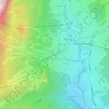
Name: Lacedèl topographic map, elevation, terrain.
Location: Lacedèl, Cortina d'Ampezzo, Belluno, Vénétie, 32043, Italie (46.51436 12.10196 46.55436 12.14196)
Average elevation: 1,396 m
Minimum elevation: 1,107 m
Maximum elevation: 2,132 m
Make a donation
Gear up for your next adventure:
As an Amazon Associate, this site earns from qualifying purchases at no extra cost to you.
Other topographic maps
Click on a map to view its topography, its elevation and its terrain.
Gruppo del Pomagagnon
Italie > Vénétie > Belluno > Cortina d'Ampezzo
Le Pomagagnon, culminant à 2 450 m d'altitude, est un chaînon montagneux des Dolomites ampezzanes, massif alpin situé en Italie (Vénétie). Il constitue la partie la plus à l'ouest du groupe du Cristallo.
Average elevation: 1,758 m
Make a donation
Gear up for your next adventure:
As an Amazon Associate, this site earns from qualifying purchases at no extra cost to you.