
Thank you for supporting this site ❤️
Make a donation
Make a donation
Gear up for your next adventure:
As an Amazon Associate, this site earns from qualifying purchases at no extra cost to you.
Elsbethen topographic map
Click on the map to display elevation.
Thank you for supporting this site ❤️
Make a donation
Make a donation
Gear up for your next adventure:
As an Amazon Associate, this site earns from qualifying purchases at no extra cost to you.
About this map
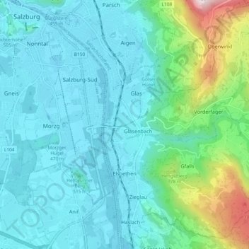
Name: Elsbethen topographic map, elevation, terrain.
Location: Elsbethen, Bezirk Salzburg-Umgebung, Salzburg, 5061, Austria (47.74049 13.07468 47.80213 13.15658)
Average elevation: 558 m
Minimum elevation: 414 m
Maximum elevation: 1,246 m
Thank you for supporting this site ❤️
Make a donation
Make a donation
Gear up for your next adventure:
As an Amazon Associate, this site earns from qualifying purchases at no extra cost to you.