
Cayambe topographic map
Interactive map
Click on the map to display elevation.
About this map
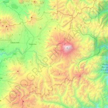
Name: Cayambe topographic map, elevation, terrain.
Location: Cayambe, Pichincha, Ecuador (-0.19557 -78.32092 0.18838 -77.83973)
Average elevation: 3,395 m
Minimum elevation: 1,900 m
Maximum elevation: 5,755 m
Other topographic maps
Click on a map to view its topography, its elevation and its terrain.
Cusubamba
Ecuador > Pichincha > Cayambe > Santa Rosa de Cuzubamba > Vista Hermosa
Cusubamba, Rodriguez, Vista Hermosa, Santa Rosa de Cuzubamba, Parroquia Santa Rosa de Cusubamba, Cayambe, Pichincha, Ecuador
Average elevation: 2,601 m