
Rivière Maskinongé topographic map
Interactive map
Click on the map to display elevation.
About this map
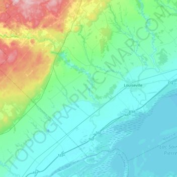
Name: Rivière Maskinongé topographic map, elevation, terrain.
Average elevation: 56 m
Minimum elevation: 1 m
Maximum elevation: 292 m
Other topographic maps
Click on a map to view its topography, its elevation and its terrain.
Maskinongé
Canada > Québec > Maskinongé (MRC) > Maskinongé (municipalité) > Maskinongé
Maskinongé, Maskinongé (municipalité), Maskinongé (MRC), Mauricie, Québec, J0K 1N0, Canada
Average elevation: 17 m