
O'More's Forest ED topographic map
Interactive map
Click on the map to display elevation.
About this map
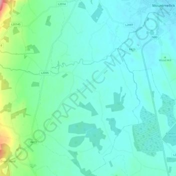
Name: O'More's Forest ED topographic map, elevation, terrain.
Average elevation: 97 m
Minimum elevation: 72 m
Maximum elevation: 216 m
Other topographic maps
Click on a map to view its topography, its elevation and its terrain.
Camira Glebe
Camira Glebe, Rosenallis ED, The Municipal District of Borris-in-Ossory — Mountmellick, County Laois, Leinster, Ireland
Average elevation: 82 m
Rathdowney
Ireland > County Laois > Rathdowney
Rathdowney, The Municipal District of Borris-in-Ossory — Mountmellick, County Laois, Leinster, R32 H773, Ireland
Average elevation: 110 m