
Blackford County topographic map
Interactive map
Click on the map to display elevation.
About this map
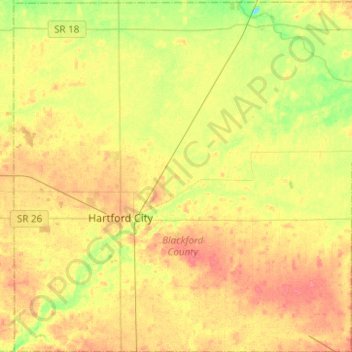
Name: Blackford County topographic map, elevation, terrain.
Location: Blackford County, Indiana, United States of America (40.37886 -85.44538 40.56792 -85.20086)
Average elevation: 274 m
Minimum elevation: 246 m
Maximum elevation: 296 m
Other topographic maps
Click on a map to view its topography, its elevation and its terrain.
Brendonwood
United States of America > Indiana > Indianapolis > Brendonwood
Brendonwood, Indianapolis, Marion, Indiana, 46226, United States of America
Average elevation: 248 m
Glenns Valley
United States of America > Indiana > Indianapolis > Glenns Valley
Glenns Valley, Indianapolis, Marion, Indiana, 46217, United States of America
Average elevation: 211 m
Fiskville
United States of America > Indiana > Fiskville
Fiskville, Montgomery County, Indiana, 47933, United States of America
Average elevation: 230 m
Rob Roy
United States of America > Indiana > Rob Roy
Rob Roy, Fountain County, Indiana, United States of America
Average elevation: 197 m
Chandler
United States of America > Indiana > Chandler
Chandler, Pike County, Indiana, United States of America
Average elevation: 151 m
Linville
United States of America > Indiana > Linville
Linville, Shelby County, Indiana, 46144, United States of America
Average elevation: 272 m
Manhattan Island
United States of America > Indiana
Manhattan Island, Vermillion County, Indiana, 47966, United States of America
Average elevation: 201 m
Kokomo
United States of America > Indiana > Kokomo
Kokomo, Howard County, Indiana, 46903, United States of America
Average elevation: 252 m
Mount Wells
United States of America > Indiana > Beverly Shores
Mount Wells, Beverly Shores, Porter County, Indiana, 46301, United States of America
Average elevation: 182 m