
Lemberg topographic map
Interactive map
Click on the map to display elevation.
About this map
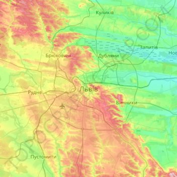
Name: Lemberg topographic map, elevation, terrain.
Average elevation: 294 m
Minimum elevation: 221 m
Maximum elevation: 431 m
Other topographic maps
Click on a map to view its topography, its elevation and its terrain.
Чортові скелі
Ukraine > Oblast Lemberg > Lemberg
Чортові скелі, Lemberg, Личаківський район, Lemberg, Oblast Lemberg, 81126, Ukraine
Average elevation: 310 m