
Larmandie topographic map
Interactive map
Click on the map to display elevation.
About this map
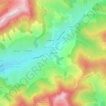
Name: Larmandie topographic map, elevation, terrain.
Average elevation: 1,167 m
Minimum elevation: 869 m
Maximum elevation: 1,580 m
Other topographic maps
Click on a map to view its topography, its elevation and its terrain.
Liadouze
France > Auvergne-Rhône-Alpes > Cantal > Mandailles-Saint-Julien
Liadouze, Mandailles-Saint-Julien, Aurillac, Cantal, Auvergne-Rhône-Alpes, France métropolitaine, 15590, France
Average elevation: 1,194 m
Puy Griou
France > Auvergne-Rhône-Alpes > Cantal > Mandailles-Saint-Julien
Puy Griou, Mandailles-Saint-Julien, Aurillac, Cantal, Auvergne-Rhône-Alpes, France métropolitaine, 15590, France
Average elevation: 1,315 m