Geolocate
👉 Easily get elevation data in JSON, GeoTIFF and KML formats using Elevation API
Thank you for supporting this site ❤️
Make a donation

Gear up for your next adventure:

As an Amazon Associate, this site earns from qualifying purchases at no extra cost to you.

Mount Hutton topographic map

Click on the map to display elevation.

About this map

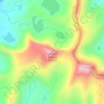
Name: Mount Hutton topographic map, elevation, terrain.

Location: Mount Hutton, Fresno County, California, United States (37.12553 -118.79963 37.12563 -118.79953)

Average elevation: 3,373 m

Minimum elevation: 3,156 m

Maximum elevation: 3,680 m

Gear up for your next adventure:

🦯Adjustable Trekking Poles - Reduce impact on knees when descending steep topographic ridges
📱Shockproof Phone Cases - Extra protection for your smartphone against drops on rocky terrain
🥾Hiking Shoes - Lightweight hiking shoes for day hikes
🔪Outdoor Multi-tools - Versatile tools for gear repair and survival tasks in the wilderness
📟Satellite Messengers - Two-way satellite communication to stay in touch beyond the cellular grid

As an Amazon Associate, this site earns from qualifying purchases at no extra cost to you.